hiking · hard
Algonquin Peak (Adirondack High Peaks)
- Distance
- 13.00 km
- Elevation
- 880 m
- Duration
- 7.0 h
- Season
- Jun–Oct
Owen here. Algonquin is the second-highest summit in New York and the centerpiece of the MacIntyre Range. It sits in the High Peaks Wilderness southwest of Lake Placid, and the standard route from the Adirondak Loj climbs hard the whole way. Twelve hundred feet of relief in the last mile or so is not unusual on this trail. Don't let the 13 km round-trip fool you into thinking it's a quick day.
The trail
From the Loj at Heart Lake, you sign in at the trailhead register and head south on the Van Hoevenberg approach before splitting off toward Algonquin. The lower section runs through classic Adirondack hardwoods — birch, beech, maple — with roots, mud, and rock slabs underfoot. After the first kilometer or so you cross MacIntyre Brook and the trail tilts up.
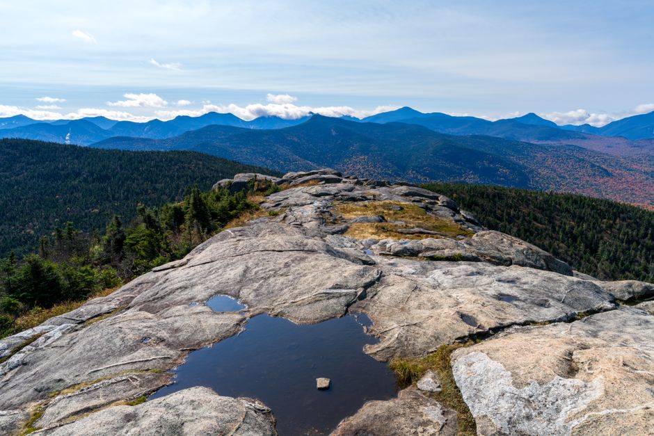
Past the junction with the Wright Peak spur, the grade gets serious. There are stretches where the trail is essentially a streambed of polished rock, and a few short scrambles where you'll be using your hands. The conifer band closes in, then thins, and you break out onto open alpine rock for the final push. The summit cone is exposed bedrock above treeline, marked by cairns and yellow paint blazes. Stay on the rock — the alpine vegetation here is fragile and slow to recover.
From the top, on a clear day, you can pick out Marcy across Avalanche Pass, Iroquois ridging off to the south, and Colden's slide-scarred face directly east. The descent is the same way you came, and your knees will know about it.
When to go
Late June through early October is the practical window for most hikers. July and August deliver the most stable weather but also the worst bug pressure in the lower forest and the busiest trailhead. September is the sweet spot — drier rock, fewer blackflies, and the hardwoods turning. Early October can be excellent but the summit can be in winter mode while the valley is still in fall; check forecasts for both.
Winter and shoulder-season ascents are a different trip entirely. The summit cone gets glazed in rime and full mountaineering gear (crampons, ice axe, layered shells) is the standard, not optional. Spring is the worst time — rotten snow, swollen streams, and trail damage. Most local stewards ask hikers to stay off until trails firm up.
What to know before you go
The Adirondak Loj road has paid parking through the Adirondack Mountain Club, and on summer weekends the lot fills before sunrise. Overflow parking exists but adds road-walking. There is no permit system for day hikes, but a summit steward is often posted on Algonquin in season — they'll ask you to keep groups tight on the bedrock and off the alpine plants.
Water is available from streams in the lower forest; treat everything. There is no reliable water above the steep section, so tank up before the climb. Cell coverage is patchy to nonexistent. The trail is well-blazed but the upper bedrock requires attention in fog — cairns and paint are your only references, and people get pulled off-route in clouds every year.
Seven hours is a fair budget for a fit hiker with breaks. Plan to be moving by 7 a.m. if you want any cushion against afternoon thunderstorms, which build fast over the High Peaks in summer.
What to bring
- Sturdy footwear with real tread — wet rock slabs are the defining hazard
- Rain shell and an insulating layer, even in July; the summit can be 15 °C colder than the trailhead with wind
- At least two liters of water per person, plus a filter if you want to top off low on the trail
- Headlamp — descents run long, and the forest goes dark earlier than you think
- Bug protection in early summer; blackflies and mosquitoes are serious below treeline
- Map and compass, and the ability to use them in whiteout conditions on the summit cone
Variations
The most common add-on is Wright Peak, picked up via the signed spur partway up — it adds roughly an hour and a second 4,000-footer to the day, with a similarly exposed summit. Stronger parties continue south from Algonquin over Boundary and Iroquois, though Iroquois is a trail-less herd path and the descent options off the back are committing. For a longer traverse, experienced hikers link Algonquin with Lake Colden and out via Avalanche Pass, turning the day into a long point-to-point with a car shuttle. If you want a shorter day instead, Wright Peak alone from the same trailhead gives you a High Peak summit at roughly two-thirds the effort.
Common questions
- How long does it take to hike Algonquin Peak?
- Budget around seven hours round-trip from the Adirondak Loj for a reasonably fit hiker, including breaks. Slower parties or anyone adding Wright Peak should plan closer to eight or nine.
- Is Algonquin harder than Mount Marcy?
- It's shorter in distance but steeper, with sustained grades and more sketchy wet-rock scrambling on the upper trail. Most hikers we know find Algonquin more physically taxing per mile, even though Marcy is the longer day overall.
- Do I need a permit or reservation to hike Algonquin?
- There's no permit for day hikes, but the Adirondak Loj parking lot is paid and managed by the Adirondack Mountain Club. On summer weekends it fills before sunrise, so arrive early or be ready to walk in from overflow.
- Can you hike Algonquin in October?
- Early October is often a strong window in the valley, but the summit cone can already be in winter conditions with rime, ice, and wind. Check both the trailhead and summit forecasts, and turn around if the bedrock above treeline is glazed and you don't have traction.
- Is Algonquin Peak doable for beginners?
- We wouldn't call it a beginner hike. It's a 13 km day with roughly 900 m of climbing, wet rock slabs, short hands-on scrambles, and an exposed alpine summit — fine for a fit hiker with some trail experience, rough for someone whose longest outing has been a flat day hike.
- Should I add Wright Peak to an Algonquin hike?
- If the weather's holding and you have legs left at the spur junction, yes — it adds about an hour and a second High Peak. Skip it if storms are building or visibility is poor on the upper bedrock, since Wright's summit is also exposed.
- How bad are the bugs on the Algonquin trail?
- Blackflies peak from late May into mid-June and mosquitoes carry through July in the lower hardwoods. By September they've largely backed off, which is one reason we point people at that month if bugs ruin your day.


